

")
Source: Link
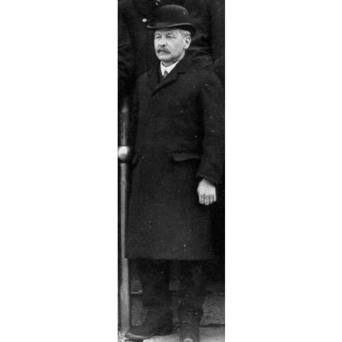
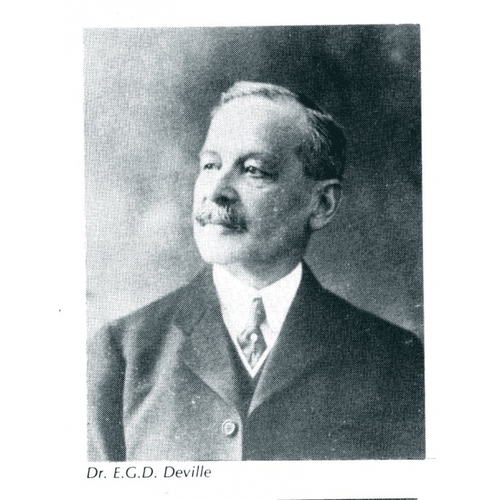
DEVILLE, ÉDOUARD (named at birth Daniel-Édouard-Gaston), surveyor, civil servant, and author; b. 21 Feb. 1849 in La Charité-sur-Loire, France, son of Charles Deville, a physician, and Estelle Tallard; m. 21 Feb. 1881 in Quebec Joséphine Ouimet, daughter of Gédéon Ouimet*, superintendent of public instruction, and they had one son; d. 21 Sept. 1924 in Ottawa.
Édouard Deville studied at the naval school in Brest and upon graduation in 1868 entered the French navy as a hydrographer. After spending several years, mostly in the South Pacific and Peru, on hydrographic surveys, he retired with the rank of captain in 1874. He immigrated to Quebec with his widowed mother and his sister that same year. Acting as astronomical assistant to Edward David Ashe*, he resurveyed parts of the upper Ottawa valley for the Quebec Crown Lands Department. He obtained his credentials as provincial land surveyor in 1877 and the next year successfully passed examinations for the commission of dominion land surveyor and the more difficult ones for the prestigious qualification of dominion topographical surveyor. These achievements brought him to the attention of Surveyor-General Lindsay Alexander Russell, who invited him to join the examining board for dominion surveyors early in 1879. Over the next year he provided Russell with examination questions and astronomical tables, and cooperated in determining the longitude of Ottawa.
Deville left the Quebec Crown Lands Department to join the federal Dominion Lands Survey in 1880. His first year found him working in the Touchwood Hills (Sask.). Such were his abilities that he was promoted inspector of surveys in 1881 and chief inspector the following year. The second position took him out of the field and into the Ottawa office. During Russell’s illness in 1884, he served as acting surveyor-general, a rank that became permanent on Russell’s retirement in 1885.
During Deville’s first year in office, his staff began surveying the mountainous Canadian Pacific Railway belt in British Columbia. Open to the potential of photography to aid in the survey of difficult terrain, he supplied one man with a survey camera in 1886 and soon developed what became known as photo-topography or photogrammetry. The first person to make this method work (it had been suggested in France in the early 1850s), he issued a guide to the new method in a limited edition in 1889. His interest in photography – he was a keen amateur photographer – also resulted in the use of copy cameras to reproduce maps for field use.
Deville was instrumental in bringing about Canada’s adherence to the International Astronomical Union and the International Union of Geodesy and Geophysics, established in 1919. Under a reorganization of the Department of the Interior in 1922, the Geodetic Survey and the international boundary commission, which had both been under the direction of William Frederick King* until his death in 1916, amalgamated with the topographical surveys branch of the department to form the Bureau of Surveys with Deville as director-general. He continued to work until April 1924, when illness forced him to remain home. During his tenure he had brought scientific rigour to his branch, had strongly supported astronomical work, had used photography increasingly, and had stimulated cartography.
Deville had been a founding fellow of the Royal Society of Canada in 1882. An active participant in its affairs, he was secretary of section iii from 1892 to 1912. His broader scientific interests led to his involvement in the Canadian Engineering Standards Association, the Town Planning Institute of Canada, the Air Board, and the Association of Dominion Land Surveyors. A long-time parishioner of Sacré-Cœur in Ottawa, he was also a member of the St Luke’s and Civic hospital boards, as well as a governor of the Alliance Française. Highly esteemed by the surveying and scientific communities, he was honoured with an lld by the University of Toronto in 1905 and the Imperial Service Order in 1916. The Engineering Institute of Canada named him an honorary member in 1922. His colleagues considered Deville an exemplary scientific civil servant and respected him for his mathematical accomplishments. He had skilfully directed a forward-looking organization, one that employed the latest techniques to deal with the significant challenges of Canadian surveying.
Édouard Deville is the author of Examples of astronomic and geodetic calculations for the use of land surveyors (Quebec, 1878) and Photographic surveying: including the elements of descriptive geometry and perspective (Ottawa, 1889; rev. ed., 1895). In addition, he contributed to the third edition of Can., Dominion lands branch, Manual shewing the system of survey of the dominion lands, with instructions to surveyors (Ottawa, 1871; [3rd ed.], 1883). These and other publications by Deville are listed in CIHM, Reg. A list of the papers he delivered before the Royal Society of Canada is available in RSC, Index to the “Transactions” and other publications, 1882–1982, comp. R. H. Hubbard (Ottawa, 1987). His reports as acting surveyor general and as surveyor general can be found in Can., Parl., Sessional papers, reports of the Dept. of the Interior, 1884–1918.
ANQ-Q, CE301-S1, 21 févr. 1881. Arch. Départementales, Nièvre (Nevers, France), État civil, La Charité-sur-Loire, 23 févr. 1849. NA, MG 29, E114, file 1; RG 15, 82; 240, file 15882. Le Droit (Ottawa), 22 sept. 1924. Globe, 22 Sept. 1924. Ottawa Citizen, 22 Sept. 1924. Ottawa Evening Journal, 22 Sept. 1924. Toronto Daily Star, 22 Sept. 1924. Canadian men and women of the time (Morgan; 1898 and 1912). J. D. Craig, “Dr. Edouard Gaston Deville, director general of surveys, Department of the Interior, Ottawa,” Royal Astronomical Soc. of Canada, Journal (Toronto) 18 (1924): 405–11. D. B. Dowling, “Edward Gaston Daniel Deville,” RSC, Trans., 3rd ser., 19 (1925), proc.: viii–ix. “E. G. Deville, i.s.o., d.t.s., hon. m.e.i.c.,” Engineering Journal (Montreal), 7 (1924): 686–87. R. A. Jarrell, The cold light of dawn: a history of Canadian astronomy (Toronto, 1988). J. G. MacGregor, Vision of an ordered land: the story of the Dominion Land Survey (Saskatoon, 1981). D. W. Thomson, Men and meridians: the history of surveying and mapping in Canada (3v., Ottawa, 1966–69), 2–3.
Image Gallery

Cite This Article
Richard A. Jarrell, “DEVILLE, ÉDOUARD (Daniel-Édouard-Gaston),” in Dictionary of Canadian Biography, vol. 15, University of Toronto/Université Laval, 2003–, accessed June 2, 2026, https://www.biographi.ca/en/bio/deville_edouard_15E.html.
The citation above shows the format for footnotes and endnotes according to the Chicago manual of style (16th edition). Information to be used in other citation formats:
| Permalink: | https://www.biographi.ca/en/bio/deville_edouard_15E.html |
| Author of Article: | Richard A. Jarrell |
| Title of Article: | DEVILLE, ÉDOUARD (Daniel-Édouard-Gaston) |
| Publication Name: | Dictionary of Canadian Biography, vol. 15 |
| Publisher: | University of Toronto/Université Laval |
| Year of publication: | 2005 |
| Year of revision: | 2005 |
| Access Date: | June 2, 2026 |